
XGRIDS · ENTERPRISE SLAM LIDAR IN STOCK
Lixel L2 Pro
Engineering-grade, in your hand.
The Lixel L2 Pro is the enterprise flagship of the Xgrids range. A 32-line SLAM LiDAR fusing LiDAR, visual sensors and IMU with AI to deliver post-processed-quality point clouds in real time, no office processing delay. Handheld, drone-mountable and vehicle-mountable, with the exclusive LixelUpSample algorithm delivering 1mm point cloud spacing, a level of detail once achievable only with static tripod scanners.
From $42,199 Inc GST


$33,759
640K pts/s
SCAN RATE
±1cm
RELATIVE ACCURACY
300m
MAX LIDAR RANGE
1mm
POINT SPACING
THREE VERSIONS
Matched to your range and density.
The L2 Pro comes in three versions. They share the same accuracy, cameras, storage and software, and differ by LiDAR channels, range and point rate.
POSITIONING
Three RTK options.
Add RTK for centimetre-level absolute accuracy, matched to how you work.
Standard RTK
Compact RTK module for projects requiring cm-level absolute accuracy. Quick-attach design.
Survey Grade RTK
Full survey-grade GNSS for the most demanding accuracy requirements. CORS-compatible.
Mini RTK
Ultra-compact RTK option for weight-sensitive applications like drone mounting.

SEE WHAT IT CAPTURES
See a L2 Pro video.
WHAT IT IS
The camera.
The Lixel L2 Pro is the enterprise flagship of the Xgrids range. A SLAM LiDAR fusing LiDAR, visual sensors and IMU with AI to deliver post-processed-quality point clouds in real time, no office processing delay. Handheld, drone-mountable and vehicle-mountable, with the exclusive LixelUpSample algorithm delivering 1mm point cloud spacing, a level of detail once achievable only with static tripod scanners. Available in three versions and three RTK options, configured to the job.
WHO IT'S FOR
The buyer.
For surveyors, engineers and AEC professionals capturing at scale: mine sites, road and rail corridors, infrastructure monitoring and large-area topographic surveys, where the highest accuracy is needed in a mobile scanner.
SPECIFICATIONS
The details.
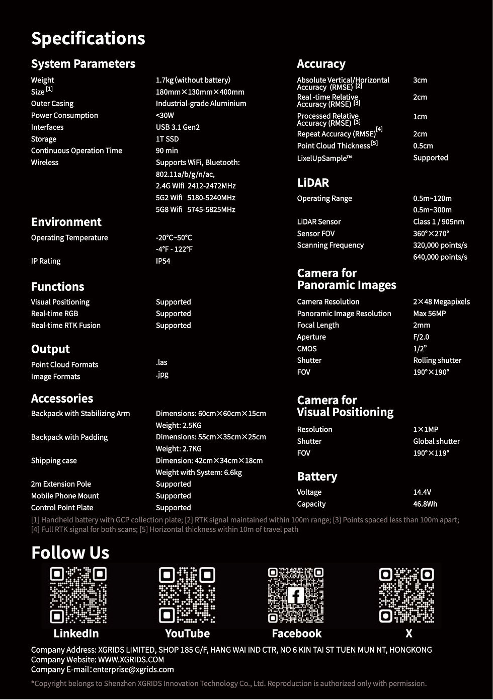
PHYSICAL
BODY WEIGHT
1.7kg
DIMENSIONS
180 × 130 × 400 mm
HOUSING
Industrial grade aluminium
INGRESS RATING
IP54
LIDAR SYSTEM
LASER CLASS
Class 1 / 905nm
SCANNING RANGE
0.5-120m / up to 300m
FIELD OF VIEW
360° × 270°
POINT RATE
320,000 / 640,000 points/second
ACCURACY
1 cm relative / 3 cm
CAMERA SYSTEM
CONFIGUTATION
Panoramic 2 × 48MP + 1MP visual positioning
IMAGE RESOLUTION
Max 56MP panoramic output
COLOUR
Real-time RGB point cloud
FIELD OF VIEW
190° × 190° panoramic · F/2.0
POWER
POWER CONSUMPTION
<30W
OPERATING TIME
90 min continuous scanning
BATTERY CAPACITY
46.8 Wh
OERATING TEMP
-20°C to 50°C
CONNECTIVITY & STORAGE
DATA INTERFACE
USB 3.1 Gen 2
INTERNAL STORAGE
1Tb SSD
RTK
Supported
WIFI RANGE
20m
CONNEXION MODE
Wifi / bluetooth
OUTPUT & SOFTWARE
PROCESSING
Automated, real-time via LixelStudio (PC) + LixelGO (app)
EXPORT
.las, .ply · 3DGS via Lixel CyberColor (LCC)
SHARING
3DGS scenes viewable in browser or VR
IN THE BOX
Scanner, battery, phone mount
PACKAGES
What's in the box.
Not every team needs to own a scanner. Kybos captures the site and delivers the browser-shareable 3D, with no hardware to buy or learn.
Enquire
Optional
BEST FOR
Where it earns its keep.
• Mine site surveying and volumetrics
• Road, rail and pipeline corridor mapping
• Infrastructure and deformation monitoring
• Stockpile volumetrics
• Large-area topographic surveys (DSM/DEM)
• Engineering measurement and construction QA

HOW TO GET ONE
For some projects, hire is the better call than purchase. Ask about availability.
FAQ
What versions of the L2 Pro are there?
How accurate is it?
What RTK options do you offer with the Lixel L2 Pro?
What are the RTK options?
How accurate is the Lixel L2 Pro?
Can it be mounted on a drone or vehicle?
Can the Lixel L2 Pro output both 3DGS and point clouds?
How much does it cost?
Can it produce 3DGS as well as point clouds?
Do you offer support and warranty?
